 1 / 3
1 / 3Property Details
Ownership Type
Unpatented Placer
Claim Type
Placer
Primary Mineral
Gold
Listed Date
June 10, 2026
Location
City
Durkee
State
OR
ZIP
97905
Country
United States
Township/Range/Section
T12S, R43E, Section 28
Description
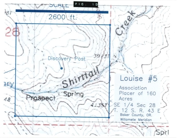
160 acre association placer containing a virgin Tertiary gravel paleo placer discovered and outlined by soil and stream sediment gold anomalies. If mined down dip 100 feet, this deposit could exceed 2,000,000 cubic yards (Fig. 2D). The source of the gold may be from erosion off the Connor Creek Thrust fault "a major regionally significant terrane-bounding structure, associated with significant gold deposits" (Google search) and (Fig. 4D). A Phelps Dodge geologist panned free gold in the area of soil anomalies and classified the deposit as a paleo placer (Data available upon request). Historic mining of a Tertiary gravel occurred approximately 3,300 feet north of our claim. This area is easily accessible via about 26 miles of interstate I84 and six miles along a graveled and maintained county road.
$39,000.00
Negotiable
Lease with an option to buy of a virgin Tertiary paleo placer. Two year lease option at $1,200 per year where Lessee has sole right to purchase property any time during the primary term. Lessee at its expense shall explore and develop the deposit to determine potential grades and will be responsible for the reclamation bond and reclamation Lessor shall have the right to audit Lessee's findings. Negotiable (NSR) Royalty between 1.5% to 3.5%. All terms are Negotiable.
Contact the Seller
Send a message to the seller. Your contact information will be shared with them so they can respond directly.